Bath, Warminster RdThe
gateway (geddit?) to 9 miles of beautiful waterside cycling
Bath - Bathampton
Note the boats and walkers. You're going to see a lot of these.
Bath - Bathampton
Perhaps the five shilling (25p) reward needs to be increased a bit...
Bath - Bathampton
Beyond the railway line (hidden below) is Hampton Row, one of the last semi-derelict terraces in Bath.
In the 1970s there were lots of buildings like this in the city.
Bath - Bathampton
The path to the left of the tree goes across to the A4 London Road, coming out near Grosvenor.
The footbridge over the canal a bit further on leads up to the MOD offices on the Warminster Road.
Bath - Bathampton
Approaching the first bridge over the canal - prepare to slow down and ring your bell
(you have got a bell, haven't you?).
Bath - Bathampton, first bridge underpass.
This is why you need to slow down and use your bell - it's narrow, you can't see who's coming and
if you meet someone head-on there's only one place to go!
Bath - Bathampton
On to the second half of the run to Bathampton - look out for the infamous Batheaston Bypass road scheme on your left!
Bath - Bathampton
Posh houses on the other side of the canal - Bathampton is one of Bath's more upmarket suburbs, handy for the University and MOD.
Bath - Bathampton
Approaching Bathampton village, and the famous (and extremely popular) George at Bathampton pub.
Bath - Bathampton
More posh(-ish) houses, but an interesting history - this is where the factory that made Plasticine modelling clay used to be.
It was built by the product's inventor, local man William Harbutt, and survived until 1983.
The George at Bathampton
Ultra-popular (if fairly expensive) canalside pub with food - it's quiet now, but it gets packed at popular times. There's a big car park at the back. The road continues over a toll bridge to the A4 at Batheaston - there's another pub/eatery by the river a few hundred yards from here.
If the pub garden's too crowded, there's this area next to it - although it gets crowded too at really popular times.
There's another bridge to negotiate, but this one's got a railing to stop you from going in!
Just beyond the bridge it gets a bit less hectic. Go left here for the safest way on to the road.
Across it is Bathampton church, back and over the bridge is Bathampton village, or just sit on the bank for a rest. It's all very picturesque.
The boat cafe (2nd along in this pic) looks nice, although it might not be permanent.
Bathampton - Dundas
Straight after Bathampton, the canal turns sharp right (with a little meandering) to head into the Limpley Stoke valley. Lots of boats here, including many that look as if they're lived in all year round.
Bathampton - Dundas
Into the valley now. Ahead is a swing bridge that doesn't really go anywhere, but has an unofficial mini-marina of moored boats beyond it. You'll see a few of these little communities along the way.
Bathampton - Dundas
The end of suburbia - things get a bit wilder from here on. The house (inset) used to serve teas but doesn't any more.
Look round the side and you'll see it's much bigger than it looks - we're halfway up the side of the valley, and it extends
downwards.
Bathampton - Dundas
The main A36 road's quite near here (above and to the right), so the idyll does get spoilt a bit by the sound of heavy trucks thundering along the valley. The trains (on the left and down) can be
surprisngly noisy too. Shame they can't all be as restful as the sound of a single-cylinder narrowboat engine.
Bathampton - Dundas
The first of the two bridges between Bathampton and Dundas. When the concrete was wet, someone immortalised their wheel tracks by riding through. They don't help when you're trying to negotiate the underpass, unfortunately.
Bathampton - Dundas
Good to see these canalside residents getting full leisure amenity value from their environment.
Bathampton - Dundas
These happy cyclists had taken the train to Bristol, and were heading home to Warminster via the Bristol-Bath and Kennet & Avon routes. That's the way to do it!
Bathampton - Dundas
It's a slower pace of life on the canal, doing the odd maintenance job on your home as it moves around the network at 4mph. All in all it does seem quite attractive...
Bathampton - Dundas, Warleigh
The big building across the valley (hidden by trees in summer) is Warleigh Manor, built in 1815 and Grade II listed.
Until a few years ago it was a very successful residential school for 'problem' children. Now it's luxury dwellings. Oh well.
Bathampton - Dundas, Warleigh
Coming up to the second bridge, and Claverton Pumping Station, where you can take an excursion to the river.
Bathampton - Dundas, Claverton
Exit left to visit Claverton Pumping Station, which pumps water 48ft up from the river to replenish the water lost through locks in Bath
(see
Wikipedia for details).
Also here is Warleigh Weir, a local bathing spot popular with young people.
Bathampton - Dundas
A fairly uneventful, but beautiful, stretch from here to Dundas - ride it on a summer evening and you'll see the boats moored up with their cabin lights on and barbecues smoking. Idyllic or what?
Bathampton - Dundas
Idyll notwithstanding, there is sometimes a need for policing on the towpath, as the presence of these (very friendly) police officers, and an abandoned motorcycle, shows. I thought they only had them on the Bristol & Bath route!
Bathampton - Dundas
A bit further on, another of those little swingbridge-and-boat communities, and this neat pub-style garden. How nice is that?
Bathampton - Dundas
Over the hump (by the swingbridge) and on to the final quarter-mile stretch to Dundas.
Dundas Basin
You've arrived at Dundas! Turn right over the bridge to continue the route, or go straight on (inset) for a little area with benches and space for picnics.
Dundas Basin
Dundas basin joins the Kennet & Avon to the Somerset Coal Canal (on the right - next pic), and provides a rare place where even a 70-ft boat can do a U-turn (just about!).
There's plenty to see here, and it's an ideal stopping place, or turning-back place for a shorter ride.
The top-right exit is the start of the Dundas Aqueduct; to the left of it is the picnic area mentioned earlier.
Dundas Basin
A slightly slippery-looking bridge takes you over the tiny Somerset Coal Canal. It's only a quarter-mile long these days, but there's something worth visiting at the end of it.
Dundas Basin
Just after the bridge take this right-hand exit - it'll take you to the exotically-named Brass Knocker Basin. For the quickest route, keep right through the wooden gate (inset). The left fork leads to the car park near the Viaduct Hotel at Limpley Stoke, a good place to join the route half-way.
Brassknocker Basin, Dundas
Cafe, shop, toilets, boat hire, car park - everything you need for a day out on the canal or a pit-stop on the cycle route. The food's been good the couple of times I've eaten there.
For the car park, turn left off the A36 from Bath at the traffic lights by the Viaduct Hotel. The car park's on the left.
Dundas
On the way back, check this out on the right - it's the Dundas Aqueduct taking the canal over the railway and river, and you'll soon be on it.
Dundas Aqueduct
Aqueducts carry canals across rivers, valleys and anything else that gets in their way. There are two on this route (the other's at Avoncliff). I still find it a bit strange to see a waterway flying over thin air like this - but fun!
Dundas Aqueduct
The River Avon below, looking upstream towards Bradford. The aqueduct opened in 1851, and was designed by the canal's architect, Scottish engineer John Rennie. He wanted to build it of brick, but local landowners insisted it was made of the more classically beautiful (but weaker) Bath stone. As a result it tended to leak and fall apart. It's been fixed now though!
For an excellent potted history of the canal,
click here.
Dundas Aqueduct
Looking downstream towards Bath.
Just beyond the aqueduct is the boathouse of the rather posh Monkton Coombe School, so any cries of "Crikey, I think Jennings Minor has drowned!" are probably just high jinks.
Dundas-Avoncliff
Round the right-hand bend after the aqueduct, and we're into wooded countryside.
Dundas-Avoncliff
20 years ago this stretch of canal was dry, and being relined with concrete. The whole Kennet and Avon canal had been condemned, but was saved by what is now the
Kennet & Avon Canal Trust, and reopened in 1990. Brilliant Job!
Dundas-Avoncliff
Out of the trees (for a while). On the hillside ahead is the village of Limpley Stoke - extremely picturesque in late evening when it's dotted with the lights of the houses.
Dundas-Avoncliff
The bridge carries the Winsley Hill road (inset) between Bradford on Avon and Limpley Stoke. There's a pub just down the hill from here.
Dundas-Avoncliff
Just after the bridge, a tea garden (open at popular times) and views across the valley to Limpley Stoke. The path is very narrow at the bridge exit.
Dundas-Avoncliff
Back into the trees for a while. There's an odd sense of space in this stretch, like riding through a big, well-lit tunnel of leaves.
Dundas-Avoncliff
Location, location, location - and the house itself looks pretty nice too.
Dundas-Avoncliff
The last bridge on the route. Take the main path to the right, instead of going under the bridge itself.
Dundas-Avoncliff
Round this final bend, then a straight run to Avoncliff.
Avoncliff
The second aqueduct, plus cafe, pub and - amazingly - a railway halt. How that's survived the rail cuts is anyone's guess.
Avoncliff
Looking downstream towards Dundas. The embankment on the right is the railway to Bath.
Avoncliff
Cafe this side (inset), and across the canal the Cross Guns pub, which is every bit as popular as the George at Bathampton.
Avoncliff
The basin allows 70ft boats to make the sharp 90-degree turn (a lot of skill is still required).
You need to get to the other side, and the first step is to turn right by the Sustrans route 4 sticker(inset).
Avoncliff - under the viaduct
Then round the hairpin bend and under the viaduct...
Avoncliff - eastern (Bradford) side
... and back up the hill. The pub does food, and has a large garden terraced down to the river. I did ride up here once, but these days I just walk!
Avoncliff - Bradford on Avon
Back on the towpath now for the final run into Bradford. Like the Bath-Bathampton stretch, this part gets very crowded at summer weekends and holidays.
Avoncliff - Bradford on Avon
Like the stretch around Bathampton, you'll see a lot of boats here that are obviously lived in rather than holiday craft. My neighbours did it - just sold up and retired to the waterways. Cold in the winter though.
Avoncliff - Bradford on Avon
Not the end of the towpath, although you can divert left into the Barton Farm Country Park just after this gate if you like. You probably don't want to know what the bridge leads to (OK, it's a sewage works!).
Bradford on Avon
It seems like remote countryside again, but really we're in Bradford-on-Avon now.
Bradford on Avon
Bradford (or "Broad-ford" over the Avon) has been a settlement since pre-Saxon times.
This is the medieval Packhorse Bridge (pedestrians and, er, packhorses only).
Bradford on Avon
This is the Tithe barn, built in the 14th Century, and used by then lords (or Abbesses) of the manor to store the 'tithe' of produce extracted fron tenant farmers as rent. Bradford on Avon has a long history; it's been a wool town and a rubber town (seriously) and is now a tourist town.
For more information
click here
Bradford on Avon
Nearly there now. Ahead on the the left is a pub, on the right a cafe and bike hire.
Bradford on Avon
The wooden gates beyond the bridge mark the end of nine miles of lock-free canal.
Bradford on Avon
Back to reality, and quite a nasty road crossing. Cross over and go right (this way) for the lock & services (through the gateway ahead). Or go left from here for the town centre,
railway station and a large car park (300 yards away). Check via
here to see which (if any) trains stopping here carry bikes.
Bradford on Avon
For some reason I think of this as the end of the Bath-Bradford route. There's another cafe, and the only properly public toilets on the route.
Bradford on Avon
Canals are normally full of locks like these, but in an amazing feat of engineering, John Rennie managed to get all the way from here to Bath without another one.
Bradford on Avon
The towpath continues on towards Devizes and Reading - but that's another ride! The hoses are for boat pump-outs. If you don't know what a pump-out is, it's better not to ask - or stand too close when one is happening.
OK, we're off...
The towpath has a loose surface, which can be dusty in summer and muddy in winter.
The first half-mile is one of the widest and smoothest sections - be ready to take care in other parts!
The towpath surface is much rougher after the bridge, although there's a narrow strip of smoother surface on the right-hand side.
The track surface gets really rough here, and it's really crowded on weekends and bank holidays.
Remember - this is primarily a pedestrian route!
The original road scheme would have meant a flyover here - bad for the canal, but good for the traffic-choked London Road and Bathwick areas. It was dropped after an enquiry.
The surface gets better again from here - and still no hills!
9 miles of canal towpath with no locks makes this the flattest bike ride you'll find
anywhere!
Say goodbye to Brunel's London-Bristol Great Western Railway, which goes straight on towards the Box tunnel. A smaller line turns right with us towards
the south coast.
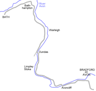
The river Avon and three transport systems run side-by side along the valley. From left to right they're river, rail, canal and road - but that changes after Dundas Basin.
We're into what
I call the 'two bridges' run from the swing bridge to Dundas (we go under two bridges). The towpath is narrow and rough in places - watch out.
There are some extra rough bits in the towpath near Claverton (rasied concrete sections and the like). Take care!
The towpath's smoother after Claverton, although it's narrow for the first half mile or so. Cyclists don't have priority over pedestrians.
Trivia - if you start playing Neil Young's album 'Harvest' at the big tree near Bath (fifth picture), and cycle at a moderate pace, the track 'Old Man (take a look at my life)' will start somewhere around here. Try it!
Get in a low gear if you're turning right over the bridge - it's surprisingly steep at the junction with the towpath!
OK, you're on the right-hand side of the canal now, and still to the right of the river and railway - but that's about to change.
The main A36 road heads away from here towards Frome and Warminster. In left-to-right order it's now the canal, river and railway.
The canal is running through wooded hillside here. The towpath is narrow in places, so take care and watch out for walkers and boat users.
The towpath widens out here, and stays fairly wide for the rest of the route. Still lots of other path users though - and lots of dust if you go too fast.
Prepare to go under the canal to continue the towpath on the other side. The route isn't obvious, but we'll show you!
It's pretty much plain sailing (or cycling) to Bradford from here. The biggest hazard is likely to be congestion at weekends.
hasn't been downloaded yet.
(You may find it better to press 'Rest, please!' and wait for all the images to be downloaded before continuing. You can see how the downloads are proceeding from the message near the bottom left-hand corner of the screen.)
Sorry, this image has failed to download. We'll keep trying to download it, so it may appear later.
This may be a problem with our server, or with your internet connection. If the image doesn't appear after a while, try reloading the page - if that doesn't fix the problem, check that you can load other pages into your browser.

 ) along the path from Bath to Bradford on Avon...